Climbing Gunung Kinabalu
Trek Essentials
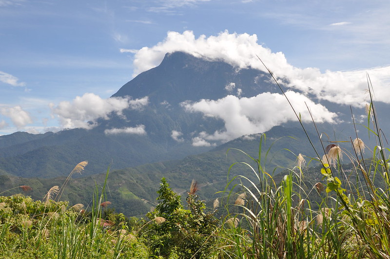
Where: Sabah, Borneo. Gunung Kinabalu is South East Asia’s highest mountain at 4,101m and forms the centrepiece of The Kinabalu Park located 90km from Sabah’s capital – Kota Kinabalu. Buses can be caught from Kota Kinabalu to the Park’s main entrance.
When: Try to avoid Borneo’s wet season between October and February
Watch out for: Fatigue, altitude sickness, near-vertical granite slopes.
Gunung Kinabalu’s saw-toothed profile dominates the landscape of northern Borneo. The summit, Low’s Peak, is named after the British explorer Hugh Low who made the first – unsuccessful – attempts to reach the summit in 1851 and then later in 1858. Local Kadazan and Dusun peoples believe that Gunung Kinabalu is the home of their dead ancestors, naming it Aki Nabalu – “Revered Place of the Dead”. Sacrifices are regularly placed at the summit to appease the restless spirits. From the far side of the summit an 1800m-drop – straight down – ends in the abyss known as Low’s Gully, infamous the world over as one of the most inhospitable places on earth.
In spite of Gunung Kinabalu’s fearsome reputation it is not a technically difficult climb and can be attempted by climbers of all fitness levels and experience. A path has been cleared through the dense jungle leading to the granite rock faces thousands of metres above where ropes have been put in place to make the final climb accessible to all.
The lower slopes of the mountain are carpeted with some of the world’s most diverse flora and fauna including the Rafflesia – the world’s largest flower (which can reach over 1m in diameter), over 1000 species of Orchids, Orang-utans, gibbons, anteaters, and hundreds of species of birds. The slopes are also home to nine species of pitcher plant. One of the largest specimens has been found containing 3 litres of water – and a drowned rat!
The Route
Most people stay in the Kinabalu Park the night before the climb, which begins at 7:00am. You will need to register at the park HQ, obtain a climbing permit and hire a guide before setting-off. These guides have lifetimes of experience climbing the mountain and can be a mine of information on the way up. When there is no work available taking tourists to the summit, the locals work as porters carrying astonishing loads up the mountain to the higher altitude huts – don’t be surprised to see them racing past with tables, crates of soft drinks and food strapped to their backs as you struggle for breath.
The trail proper begins at the Timpohon Gate, a few kilometres from the HQ, and begins deceptively as you stroll down hill through lush tropical rainforest and a beautiful waterfall before heading steadily upwards. Rest stops are dotted along the entirety of the path, often with stunning views back down the mountain. After about 1250m the vegetation begins to change to more temperate forests of oaks, chestnuts, and ferns, and as you climb higher and higher the trees begin to thin, until at 2,600m they are no more than gnarled and twisted stumps. The root-covered steps are hard work but the views behind you are stunning.
At 3,300m the tree line disappears as you emerge from the forest and get your first glimpse of the massive granite rock faces ahead of you. Most people stop here for the night, at the Laban Rata rest house or the more basic huts at Gunting Lagadan and Panar Laban. You should be able to get to this point by mid-afternoon.
Many climbers suffer from altitude sickness at this height, characterised by headaches and nausea, and stop to acclimatise – and get some sleep before the 2am start the following day. An early departure from Laban Rata is essential to catch the awesome sunrise from the summit, but the climb can be difficult in the dark. Everyone assembles in the blackness before setting off for the summit between 2-3am. A torch is handy, as are warm clothes and gloves – the summit can be cold, especially after the climb when you start to cool off.
Parts of this section are hard work involving hauling yourself up near-vertical rock faces with ropes. Huge granite sheets fan out across the mountain before you reach the summit and can only be fully appreciated on the way down when you can actually see them in the light of day. Reaching the horn-shaped summit, the climbers huddle together for warmth and watch the sun rise over Borneo thousands of metres below. On a clear day you can see the coast and the islands of Tunku Abdul Rahman Park from Low’s Peak.
Travellers Tips
▪ If you are travelling alone, team-up with some others to make hiring the guide cheaper.
▪ Take a torch – the second part of the climb is in the middle of the night.
▪ Coming down can cause severe muscle strains and fatigue – take your time on the way up and on the way down.
▪ Take plenty of food – especially high-energy munchies like chocolate.
▪ Make use of the Laban Rata rest house, which has hot water, hot food and beds and a great spot to watch the sunset before getting some rest.
Further Information
Sabah Tourism: www.sabahtourism.com
51 Jalan Gaya, 88000 Kota Kinabalu, Sabah, Malaysia