Volcanoes of the Pacific North West
The US Pacific States of California, Oregon and Washington are home to their own Avenue of the Volcanoes – four huge and picturesque volcanoes clearly visible as you drive south from Seattle to San Fransisco.
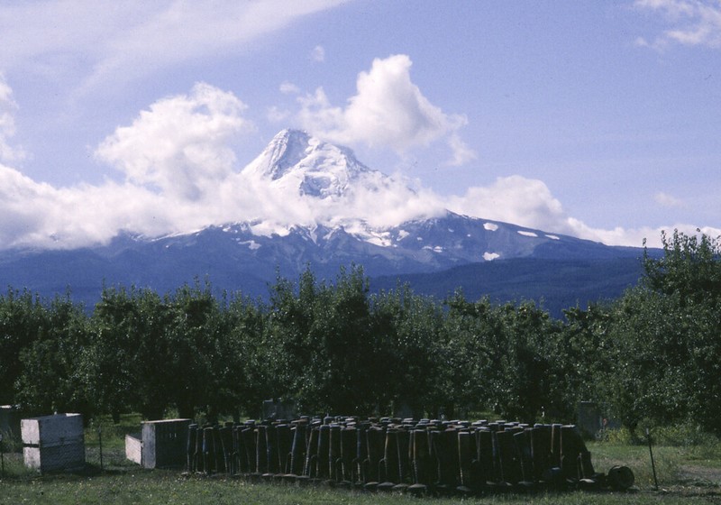
*Mount Hood
One hours drive out of the Portland , go skiing on the volcanic peak of Mount Hood, rising like a white incisor out of the earth. A dormant volcano, the mountain is surrounded by an immense national forest, making it the perfect area for snow sports, trekking, and other recreational activities. At 11,239 feet, Mount Hood stands the tallest peak in Oregon.
You can ride the scenic railroad and there is Year round skiing.In fact, it is the second-most climbed peak over 10,000 after Japan’s Mt Fuji. Most Oregonians don’t feel complete unless they climb this mountain at least once in their lives. The best time is between May and mid-July It takes 10-12 hours.
*Mt Rainier
– Mt. Rainier is considered the longest endurance climb in the lower 48 states. At 14,411 feet (nearly three miles high), Rainier is the tallest volcano in the Cascade Range. The Cascade mountain range stretches from Mount Garibaldi in Canada’s British Columbia, to Lassen Peak in northern California.
Mt. Rainier is also the most extensively glaciated volcanic peak in the continental USA.. It is an active volcano, and the most recent documented eruption was a relatively small one during the early to mid-1800s. At one time, Rainier was 16,000 feet above sea level, but an eruption 5800 years ago blew its top off, spewing a wall of mud across 125 square miles of surrounding countryside and creating the Osceola Mudflow. The last major eruption occurred 2500 years ago, which created a second volcanic cone at its summit. You can still see how the two craters overlap at Columbia Crest, and the remains of the older cone can be seen at Liberty Cap and Point Success
*Mount St Helens
No trip to this area of the world would be complete without visiting Mount St. Helens, the volcano with a mammoth history.
The Mount Saint Helen National Volcanic Monument covers 172 square miles around the mountain following its eruption.
You can visit Coldwater Ridge Visitor Centre and Johnson Ridge Observatory for up-close views of the volcano crater .Windy Ridge provides even more spectacular views, though it is difficult to access.
The area is now laced by hiking trails. Ape Cave Trail passes through the longest lava loop in the 48 contiguous states . The USGS (United States Geological society) have a bunker at Harrys Ridge to observe the volcano. You can climb to this.
Climbing permits are required . Visit www.fs.fed.us/gpnf/recreation/mount-st-helens/index.shtml
*Mount Shasta is a potentially active volcano at the southern end of the Cascade Range in Northern California .At an elevation of 14,179 feet , it is the second-highest peak in the Cascades and the fifth-highest in the state. Mount Shasta has an estimated volume of 85 cubic miles (350 cubic kilometers), which makes it the most voluminous stratovolcano in the Cascade Volcanic Arc. The mountain and surrounding area are part of the Shasta–Trinity National Forest.
The mountain consists of four overlapping dormant volcanic cones that have built a complex shape, including the main summit .