Volcanoes
Volcanoes have fascinated mankind for generations – their enormous beauty and destructive power revered in awe. They have been worshiped, immortalized in folklore and voraciously studied by geologist throughout the centuries.
Volcanoes have also contributed to an enormous amount of destruction of life from early records of primitive man fleeing from lava flows, or even further back in time when the Permian–Triassic extinction occurred 250 million years ago caused by volcanoes in Siberia which pumped out almost ten giga-tonnes of carbon as carbon dioxide during its eruption. The global warming that followed wiped out four fifths of all sea life and it took 5 million years for the planet to recover. Nonetheless, it looks like volcanoes are here to stay with approximately 15,000 volcanoes accounted for today all around the world!
The earliest known recording of a volcanic eruption may be on a wall painting dated to about 7,000 BCE found at the Neolithic site at Çatal Höyük in Anatolia, Turkey. This painting has been interpreted as a depiction of an erupting volcano, with a cluster of houses below shows a twin peaked volcano in eruption, with a town at its base. However, archaeologists now question this interpretation. The volcano may be either Hasan Dağ or its smaller neighbour, Melendiz Dağ.
Types Of Volcanoes
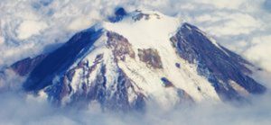
When thinking of a volcano, the first thing that usually comes to mind is a colossal, cone shaped mountain that emits massive amounts of lava. However, various types of volcanoes exist beyond this common perception.
A fissure volcano has no central crater at all, but rather, giant cracks open in the ground that eject immense amounts of lava with typically no explosive activity. This lava spreads far and wide distances to form gigantic pools that can cover almost everything around and can cause flood basalts and lava channels. Hawaiian volcanoes produce what’s known as “curtains of fire” because of the lava fountains that erupt along a portion of the fissure.
Cinder cones or scoria cones are simple volcanoes, which have a bowl-shaped crater at the summit and steep sides. These volcanoes are glassy and contain numerous gas bubbles “frozen” into place as magma explodes into the air and then cools quickly. Cinder cones range in size from tens to hundreds of meters tall and Cinder cones are made of pyroclastic material.
In a cinder cone, lava erupts from a small vent in the crust and ‘sprays’ melted rock fragments into the air where they then fall back to earth in a pile. These rock fragments are glassy, gas-filled chunks of lava called cinders or scoria that cool swiftly as they float through the air and land next to the vent opening, gradually accumulating in the geometric shape of a cone. Two famous cinder cones are Paricutin in Mexico and the one in the middle of Crater Lake in Oregon.
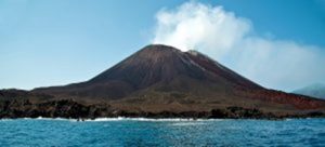
Shield volcanoes are usually built almost completely of fluid lava flows. They are named for their large size and low profile, resembling a warrior’s shield lying on the ground. They are tall and broad with flat, rounded shapes and have low slopes and almost always have large craters at their summits. Shield volcanoes are the largest volcanoes on Earth that actually look like volcanoes.
The Hawaiian shield volcanoes are the most famous examples. The largest is mauna loa on the Big Island of Hawaii; all the volcanoes in the Hawaiian Islands are shield volcanoes. Shield volcanoes are almost exclusively basalt, a type of lava that is very fluid when erupted. They are characterized by low-explosive fountaining that forms cinder cones and spatter cones at the vent, however 90% of the volcano is lava rather than pyroclastic material. Other shield volcanoes are also found in Washington, Oregon and the Galapagos Islands.
Composite volcanoes are much more explosive than shield volcanoes. These large and characteristically cone-shaped volcanoes form along plate boundaries called subduction zones where one of the Earth’s plates moves below another. They are built of alternating layers of lava flows, volcanic ash and cinders. A few famous composite volcanoes include Mt. Fuji in Japan, Mount St. Helens and Mount Rainier in Washington state as well as Mount Etna in Italy.
The Geology Of Volcanoes
The surface of the Earth is made up of rigid plates that move at a rate of a mere few centimetres each year. Upon colliding with each other, one plate can be pushed beneath another. As the plate descends it heats up and dehydrates, which allows for water to be released from minerals and cracks in the submerged plate. This water is hotter than the surrounding rocks and rises up into the mantle. Then, the accumulation of these hot fluids lowers the pressure and causes the mantle rocks to melt. This molten rock then escalates and erupts on the surface building up a volcano.
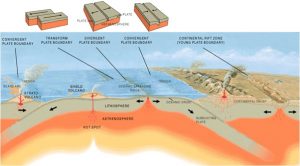
Additionally, volcanoes also form when plates move apart. Magma ascends up and erupts on the surface as lava in the area that the plates separate. Due to this reason, volcanoes are often found along plate edges. These areas include: the Pacific plate, North and South America, Japan and the Philippines. Sometimes volcanoes can form in the middle of a plate like Hawaii. Hawaii is there because of a hot mantle plume, which rises up from very deep in the mantle, bringing hot magma to the surface. A mantle plume is defined as an upwelling of abnormally hot rock within the Earth’s mantle.
These two types of volcanic formations can be found in the Mid Atlantic Range, where the tectonics plates are diverging from each other. On the other hand, Pacific Rim of Fire is an example of a volcano caused due to the convergence of tectonic plates.
The Ring Of Fire
The large chain of underwater volcanoes (some active) surrounding the Pacific Ocean are referred to as being part of the Ring of Fire, and notorious for frequent earthquakes and volcanic eruptions. The ring of fire is a horseshoe shaped area in the Pacific Ocean, which extends from South America and North America to Eastern Asia, Australia and New Zealand. This area is famous for its regular seismic activity and because of the quantity of active volcanoes that can be found here. 75% of dormant and active volcanoes are found in the Pacific Ring of Fire.
It is alleged that the Pacific Ring of Fire has a total of 452 volcanoes. Kilauea is located in this area and is classified as the most active volcano in the world. Other noteworthy volcanoes are Mt. Fuji in Japan, Mt. Saint Helens and Mt. Rainier in the American North West, Krakatoa in Indonesia, Mauna Loa in Hawaii, Galeras in Colombia and Sangay in Ecuador.
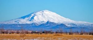
Some volcanoes are more dangerous than others and would cause greater consequences for the land and people surrounding the area if one of these volcanoes erupted. For example, if Mt. Rainier were to erupt, the 2.5 million people in the area surrounding Seattle and Tacoma would have to evacuate fast. The snowy cap of the volcano could possibly add to the danger and make things worse.
Mount Rainier, Washington by Ron Reiring, Flickr Creative Commons
The Santa Maria Volcano in Guatemala proved its extreme power in the 20th century and was identified as one of the most tragic eruptions, occurring in 1902. If an eruption were to happen again in the present, due the increase in population, a much greater percentage of the people would be impacted.
One additional mountain, Mount Yasur in Vanuatu is labeled a stratovolcano and has been erupting for a hundred years. Even though this volcano represents a great deal of danger, tourists continue to flock to this crater despite the toxic gases and lava flows that are emitted. In fact, this volcano has already claimed a few lives from tourists and a tour guide who infiltrated this danger zone.
Today, the Pacific Ring of Fire is much different than it was thousands of years ago due to the changes caused by tectonic plates. The Pacific Plate will hit other plates nearby, which causes them to sink. Then, the crust melts and produces the magma that nourishes the various volcanoes or creates new volcanoes. Additionally, the tectonic plates are also the cause for the multiple vicious earthquakes in all of the pacific.
After the Ring of Fire, the next most seismically active region is the Alpide Belt. This belt extends from Java to Sumatra through the Himalayas, the Mediterranean, and out into the Atlantic. This region contains 5% of earthquakes and 17% of the world’s largest earthquakes. Mid-Atlantic Ridge is the third most leading earthquake belt.
Iceland
In few places on earth, geology and human history are so closely connected to volcanism as on Iceland. The island owns its existence to a large volcanic hot spot sitting on a mid-oceanic ridge, which is a rare locale. Iceland is also known to contain volcanoes and earthquakes. Shattering earthquakes occur at longer intervals than the volcanic eruptions. Some of the most terrible earthquakes devastated huge areas of southern Iceland in 1784 and 1896. The central plateau contains over a hundred volcanoes, which have not erupted in the past thousand years and approximately 30 to 40 that are active and have erupted within the last few centuries.
Mt Hekla by Finnur Bjarki Tryggvason, Flickr Creative Commons
Iceland’s three chief volcanoes include: Hekla, Katla and Grimsvotn – lie along this boundary. Offshore volcanic activity has resulted in the creation of separate volcanic islands. One of these, named Surtsey appeared fairly recently in 1963. Mt. Hekla has erupted 18 times since 1104 and 2000 was the last recorded eruption.
Icelandic volcanoes have a reputation for drawing tourists from across the globe, ready to catch a glimpse of a pillar of smoke or an impressive lava flow. However, there have also been disastrous events. Eruptions at the eastern volcanoes of Grimsvotn and Laki from 1783 to 1785 produced a lava flow, which consumed vast strips of land, dulled out the sun and killed a quarter of the population through poisoning or famine.
Even volcanoes that were assumed to extinct a long time ago and had not been active for approximately 5,000 years, unexpectedly in 1973. Moreover, Heimaey is the largest of the Vestmanneyjar Islands and the sole one that is inhabited. Heimaey, a fishing town with a population of 5,300 was just 200-300m away from the eruption. This eruption began at night on January 23 and almost all of the inhabitants were evacuated, while only a few hundred stayed behind. This eruption lasted five months and although the village was practically destroyed by lava, ash and fire, two-thirds of Heimaey was saved by using barriers and huge jets of water to cool down the lava. Surprisingly, when the eruption came to an end, the town’s harbor was even better than before, providing greater protection from wind and water. Eventually, people began to move back and resume life as it once looked.
Additionally, other well known eruptions in Iceland include a submarine eruption that occurred on the Reykjanes Ridge in 1963, which formed a new island, Surtsey, which forms part of the same archipelago as Heimaey. Lakagigar, located southwest of Vatnajokull, discharged 3 cubic miles of lava, which was known as the peak lava flow observed on Earth. Many of the animals died from the poisonous gases and the extended famine resulted in the deaths of 20% of the population.
One positive thing that volcanoes produce in Iceland is that they supply an continuous supply of geothermal energy. Just over 90% of housing in Iceland is heated by natural geothermal heat. This is one of the cheapest and cleanest forms of energy. Due to this clean energy; Iceland remains the most unpolluted country.
Krakatoa
The eruption of Krakatoa occurred on August 26, 1883 in the Dutch East Indies, now known as Indonesia. Then, on August 27th, two thirds of Krakatoa collapsed in a sequence of epic explosions, which destroyed most of the island and its surrounding archipelago. This seismic activity continued to be reported until February 1884, but this information was later rejected. This eruption was one of the deadliest and most destructive volcanic events recorded in history. The destruction culminated in at least 36,417 deaths. They were classified as the result of the eruption as well as the tsunamis it created.
Mt Krakatoa by Michael Newman, Flickr Creative Commons
Several months earlier, inhabitants of the coastal plains of Java and Sumatra would witness spectacles of explosive noise and churning clouds of black to glowing ash and pumice. From a distance, the largest of these natural displays impressed these local inhabitants, which created an almost festive environment. However, they did not realize that these tremendous displays were only a prelude to one of the largest eruptions in historic times.
Kīlauea
Kīlauea is a shield volcano located in the Hawaiian Islands. This is the most active volcano out of the five that compose the island of Hawai’i. This volcano is also the second youngest creation of the Hawaiian hotspot and is the current eruptive center of the Hawaiian Emperor seamount chain. The makeup of Kīlauea has a large, fairly recently formed caldera at its summit and two active rift zones, one that extends 125 km east and the other one is 35 km west, as an active fault line of unknown depth moving vertically an average of 2 to 20 mm per year.
Presently, Kīlauea volcano is still having one of the most long-lived eruptions known on earth. Not only is it the most active volcano in Hawaii, it is also the most active volcano in the world. Many of the eruptions are well known in Hawaiian Polynesian legends and written documentation about its activity date back only to the 1820s due to the fact that it started to attract interested visitors from all over the world and became one of volcanology’s hot spots.
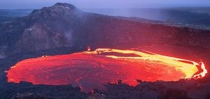
Lava lake inside Kilauea volcano, Hawaii by Tom Pfieffer, Flickr Creative Commons
Many of the members of Hawaii Centre for Volcanology are working on Kīlauea or have gained insights into the nature of volcanoes upon visiting it. In contrast to most other active volcanoes, Kīlauea is approachable. It has been called the “drive-up” volcano because of the ease of access to many of its areas of volcanic activity, especially the summit caldera.
The eruption of Kīlauea volcano continues from two locations. In the park, the summit eruption of Kīlauea within Halema’uma’u Crater continues to offer the greatest, safest, and easiest eruption viewing. The second location stems from from the Pu’u ‘Ō’ō vent in the isolated east rift zone, with all flows in dangerous forest reserves that are closed to the public (the Kahauale‘a 2 flows.) Currently there is no reported lava flowing into or in the direction of the ocean.
Cotopaxi
Cotopaxi in Ecuador is one of South America’s most famous volcanoes and one of its most active ones. It reaches 5911 meters high and with its incredible height, Cotopaxi ranks among the world’s highest volcanoes, coming in at number 26. The grandiose snow covered, proportioned stratovolcano is located on the Eastern Cordillera of the Ecuadorian Andes. It’s located 60 km south of Quito and 35 km northeast of Latacunga.
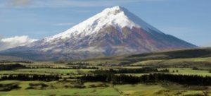
Mt Cotopaxi by Dave Lonsdale, Flickr Creative Commons
It’s a known fact that Cotopaxi erupted more than 50 times since 1738. The most violent historical eruptions of Cotopaxi volcano were in 1744, 1768, 1877, and 1904. Its eruptions often created pyroclastic flows and disparaging mud flows (lahars). Some lahars have travelled more than 100 km and reached the Pacific to the west and the Amazon Basin to the east. Presently, it has been inactive for over 70 years, which is an unusually long interval in its recent history.
There have been numerous eruptions of this volcano. One ancient eruption in 1534 caused the inhabitants to interpret the reason behind the eruption in a surprising way. The conquistadors were at war with the locals for control over Ecuador. It is described that during a battle on the flanks of Cotopaxi, the volcano started an eruption and packed the air with “hot ash.” The locals interpreted the event as a divine sign from their god and took off in fear. The Spanish who had no experience with volcanic activity were frightened and followed suit. Several other eruptions followed in 1742, 1768, 1877, 1907 and quite a few more in between.
Mount Fuji
Mount Fuji is the tallest mountain in Japan, standing at 3,776 meters or 12,380 feet and an icon of the country. It is also the 35th most prominent mountain in the world. It contributes to Japan’s physical, cultural and spiritual geography. This active volcano sits on a “triple junction” of tectonic activity. The three plates are: the Amurian plate, which is associated with the Eurasian tectonic plate, the Okhotsk plate, associated with the North American plate and the Filipino plate all unite in the region beneath Mount Fuji. Surprisingly, it is very close to Tokyo, Japan’s largest city, stretching a mere 100 kilometers or 62 miles away.
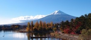
Mount Fuji, Lake Kawaguchiko by Guilhem Vellut, Flickr Creative Commons
Each year, more than 200,000 people climb to the top of Mount Fuji. The first known ascent was by a monk in 663. The first known Westerner to climb this mountain was Sir Rutherford Alcock in September of 1860. Following the first ascent, only men regularly climbed the peak. Women were not allowed on the summit until the Meiji Era in the late 19th century and the first woman to pave the way for others was Lady Fanny Parkes in 1867.
During the climb up, there are huts that accommodate climbers. These huts provide refreshments, basic medical supplies, and room to rest. It is common that climbers begin their ascent during the night to be able to catch the sunrise from the summit, which also coincides with Japan’s nickname, “the Land of the Rising Sun.” This sunrise is labeled Goraiko.
In 2004, a Japanese government simulation verified that in the worst-case scenario, a major eruption of Mount Fuji would result in ¥2.5 trillion in economic damage. The most recent eruption occurred back in 1707, which began with an earthquake of an 8.4 magnitude in Honshu, Japan. Several less significant earthquakes occurred after, followed by an eruption, triggered on December 16, 1707 on the south east flank of the volcano joined with pumice fall. After a long six hours the pumice fall switched into scoria fall. On the first day of the eruption, 72 houses and three Buddhist temples were ruined in the town of Subassiri 10 km from the volcano.
Even today in 2014, volcanoes are continuously monitored by scientists to determine their activity. There have been many studies about whether or not volcanic eruptions can help with cooling down the earth and assist in combating global warming.
When volcanoes erupt, they can emit hefty amounts of sulfur dioxide, which acts to make the atmosphere more opaque, thus shielding the planet from some of the sun’s incoming radiation. This effect can hypothetically offset some of the influence of manmade greenhouse gases, which trap heat inside the atmosphere and warm the planet. However, there have been studies that dispute this and others that support it. One scientist, Ryan Neely claims that “tropical eruptions are usually more effective at cooling the climate compared to a high latitude eruption that is the same size, because it has the potential to impact both hemispheres and the aerosol topically stays in the atmosphere longer”. Today, scientists continue to monitor and study volcanic activity, however the way these volcanoes will unfold in the next decade is still uncertain.